| Category 4 hurricane (SSHS) | |
|---|---|
| |
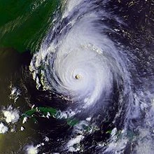
| Hurricane Floyd over The Bahamas on September 14, 1999 | |
| Formed | September 7, 1999 |
| Dissipated | September 19, 1999 |
| Highest winds | 1-minute sustained:
155 mph (250 km/h) |
| Lowest pressure | 921 mbar (hPa; 27.2 inHg) |
| Fatalities | 57 direct, 20–30 indirect |
| Damage | $4.5 billion (1999 USD) |
| Areas affected | The Bahamas, U.S. East Coast from Florida to Maine (particularly North Carolina), Atlantic Canada |
| Part of the 1999 Atlantic hurricane season | |
Hurricane Floyd was the sixth named storm, fourth hurricane, and third major hurricane in the 1999 Atlantic hurricane season. Floyd triggered the third largest evacuation in US history (behind Hurricane Gustav and Hurricane Rita, respectively) when 2.6 million coastal residents of five states were ordered from their homes as it approached. The Cape Verde-type hurricane formed off the coast of Africa and lasted from September 7 to September 19, peaking in strength as a very strong Category 4 hurricane—just short of the highest possible rating—on the Saffir–Simpson Hurricane Scale. It was among the largest Atlantic hurricanes of its strength ever recorded.
Floyd struck The Bahamas at peak strength, causing heavy damage. It then paralleled the East Coast of the United States, causing massive evacuations and costly preparations from Florida through the Mid-Atlantic states. The storm weakened significantly, however, before making landfall in North Carolina as a Category 2 hurricane, and caused further damage as it traveled up the Mid-Atlantic region and into New England.
The hurricane produced torrential rainfall in eastern North Carolina, adding more rain to an area hit by Hurricane Dennis just weeks earlier. The rains caused widespread flooding over a period of several weeks; nearly every river basin in the eastern part of the state exceeded 500-year flood levels. In total, Floyd was responsible for 57 fatalities and $4.5 billion (1999 USD; $5.93 billion 2011 USD) in damage.
Meteorological History[]
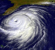
Satellite image of Hurricane Floyd.
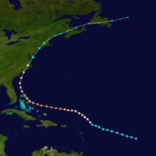
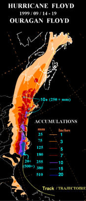
Storm Path.

.jpg)
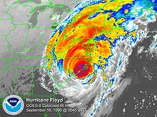
Hurricane Floyd at its North Carolina landfall.
Floyd originated as a tropical wave that exited the coast of Africa on September 2. It moved steadily westward and remained disorganized and devoid of deep convection until September 7, when a curved band of deep convection developed over the center in response to a developing anticyclone. At this point, the National Hurricane Center designated it as Tropical Depression Eight, while it was approximately 1,000 mi (1,600 km) east of the Lesser Antilles. A strong ridge of high pressure to its north forced the developing tropical cyclone westward over warmer waters, allowing it to strengthen to Tropical Storm Floyd on September 8.
Although a large storm, Floyd initially lacked a well-defined inner core, resulting in slow strengthening and preventing rapid intensification. On September 10 it organized enough to reach hurricane status, and Floyd approached major hurricane strength on September 11 while north of the Leeward Islands. The central Atlantic upper tropospheric trough, along with an upper-level low in the eastern Caribbean Sea, produced vertical wind shear over the hurricane and caused its winds to weaken to 85 mph (137 km/h). A turn to the west, caused by building of high pressures, was followed by a period of rapid intensification: in 24 hours maximum sustained winds increased from 110 mph (180 km/h) to 155 mph (249 km/h), while the pressure dropped to 921 millibars (27.2 inHg) by morning on September 13. One contributor to the intensification was the high oceanic heat content along the storm's path.
Hurricane Floyd remained just below Category 5 status on the Saffir–Simpson Hurricane Scale for 12 hours while crossing the Bahamas, making landfalls on Eleuthera and Abaco islands, before an eyewall replacement cycle weakened it to a Category 3 hurricane with winds of 120 mph (190 km/h). The new, larger eyewall contracted slightly, and the hurricane briefly re-intensified to Category 4 status. A strong mid- to upper-level trough eroded the western portion of the high-pressure ridge, steering Floyd to the northwest. It paralleled the eastern Florida coast 110 miles (180 km) off shore, and steadily weakened because of entrainment of dry air and upper-level shear. The storm remained extremely large, however; at its peak, tropical storm-force winds spanned a diameter of 580 mi (930 km), making Floyd one of the largest Atlantic hurricanes of its intensity ever recorded.
Floyd accelerated to the north and northeast, and weakened greatly to a Category 2 hurricane with 105 mph (169 km/h) winds at its Cape Fear landfall on September 16. After crossing over North Carolina and southeastern Virginia, it briefly re-entered the western Atlantic Ocean before reaching Long Island on September 17. The storm gradually lost its tropical characteristics due to an approaching frontal zone and became extratropical over southern Maine late on September 17. The extratropical storm continued to the northeast, and after passing over the Canadian Maritimes, it was absorbed by a cold front to the east of Newfoundland.
Preparations[]
Although Floyd's track prediction was above average while out at sea, the forecasts as it approached the coastline were merely average compared to forecasts from the previous ten years. The official forecasts did not predict Floyd's northward track nor its significant weakening before landfall. Nearly all of the East Coast, from Florida City, Florida, to Plymouth, Massachusetts, was under a Hurricane Warning at some point; however, only a fraction of this area actually received hurricane-force winds. The last time such widespread hurricane warnings occurred was during Hurricane Donnain 1960, although the warnings for that storm were accurate.

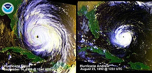
Visual comparison of Floyd with Hurricane Andrew while at similar positions and nearly identical intensities.
Initial fears were of a direct hit as a large Category 4 hurricane in Florida, potentially costlier and deadlier than Hurricane Andrew had been in 1992. In preparation for a potentially catastrophic landfall, more than one million Florida residents were told to evacuate, of which 272,000 were in Miami-Dade County. U.S. President Bill Clinton declared a federal state of emergency in both Florida and Georgia in anticipation of the storm's approach. As the storm turned to the north, more people were evacuated as a progressively larger area was threatened. The massive storm caused what was at the time the largest peacetime evacuation ever in the U.S., with around 2.6 million evacuating coastal areas in Florida,Georgia, and the Carolinas. With the storm predicted to hit near Cape Canaveral with winds of over 140 mph (230 km/h), all but 80 of Kennedy Space Center's 12,500-person workforce were evacuated. The hangars that house three space shuttles can withstand winds of only 105 mph (169 km/h), and a direct hit could have resulted in potentially billions of dollars in damage of space equipment, draining funds of an already money-strained government organization. In the theoretical scenario, the damage would be caused by water, always a potential problem in an area only nine feet above sea level. If water entered the facility, it would damage the electronics as well as requiring a complete inspection of all hardware. When Floyd actually passed by the area, Kennedy Space Center only reported light winds with minor water intrusion. Damage was minor overall, and was repaired easily.
A hurricane warning was issued for the North Carolina coastline 27 hours prior to landfall. However, due to the size of the storm, initial forecasts predicted nearly all of the state would be affected in one form or another. School systems and businesses as far west as Asheville shut down for the day landfall was predicted, but, as it turned out, only the Coastal Plain sustained significant damage; much of the state west of Raleigh escaped unscathed.
In New York City, public schools were closed on September 16, 1999, the day Floyd hit the area. This was a rare decision by the city, as New York City public schools close on average once every few years. Before Floyd, the last time New York City closed its schools was for the Blizzard of 1996. After Floyd, the next time its public schools would close was due to the September 11, 2001 terrorist attacks.
Impact[]
With a death toll of 57, Hurricane Floyd was the deadliest United States hurricane since Hurricane Agnes in 1972. The storm also was one of the costliest in the nation's history, amounting to $4.5 billion (1999 USD; $5.3 billion in 2006 U.S. dollars). Most of the deaths and damage were from inland, freshwater flooding in eastern North Carolina.
| State/country | Deaths |
|---|---|
| The Bahamas | 1 |
| North Carolina | 35 |
| Virginia | 3 |
| Delaware | 2 |
| Pennsylvania | 6 |
| New Jersey | 6 |
| New York | 2 |
| Connecticut | 1 |
| Vermont | 1 |
| Total | 57 |
Bahamas[]
Hurricane Floyd lashed the Bahamas with winds of 155 mph (249 km/h) and waves up to 50 ft (15 m) in height. A 20 ft (6.10 m) storm surge inundated many islands with over five ft (1.5 m) of water throughout. The wind and waves toppled power and communication lines, severely disrupting electricity and telephone services for days. Damage was greatest at Abaco Island, Cat Island, San Salvador Island, and Eleuthera Island, where Floyd uprooted trees and destroyed a significant number of houses. Numerous restaurants, hotels, shops, and homes were devastated, severely limiting in the recovery period tourism on which many rely for economic well-being. Damaged water systems left tens of thousands across the archipelago without water, electricity, or food. Despite the damage, however, few deaths were reported, as only one person drowned in Freeport, and there were few injuries reported.
To help the affected citizens, the Bahamian Red Cross Society opened 41 shelters, though within one week many returned home. The Bahamas required $435,000 (1999 USD; $573 thousand 2011 USD) in aid following the storm, much of it in food parcels. The Inter-American Development Bank loaned $21 million (1999 USD; $27.7 million 2011 USD) to the archipelago to restore bridges, roads, seawalls, docks, and other building projects in the aftermath of the hurricane.
Southeastern United States[]
Although over a million Florida residents were evacuated, the state was only lightly affected by Hurricane Floyd. Strong waves and tropical storm-force winds resulted in significant beach erosion on the east coast of Florida, as well as the loss of some boat piers in Brevard and Volusia Counties. Moderate rainfall occurred along the coastline, amounting to a maximum of 3.2 in (81 mm) in Sanford. Floyd's winds downed hundreds of trees, damaging 357 houses. Damage in northeast Florida amounted to $46.5 million (1999 USD; $61.3 million 2011 USD), a fraction of what was originally expected.The states of Georgia and South Carolina, although threatened by the storm, were largely spared when it turned northward. Some areas of eastern South Carolina reported up to 16 in (410 mm) of rain.
North Carolina[]
'
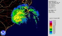

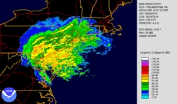
Radar imagery of Hurricane Floyd making landfall in North Carolina.


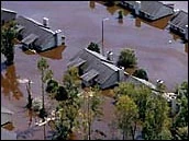
Coastal property damage at Pine Knoll Shores, North Carolina.
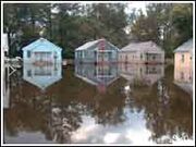
'North Carolina received the brunt of the storm's destruction. In all, Hurricane Floyd caused 35 fatalities in North Carolina, much of them from freshwater flooding, as well as billions in damage.
The storm surge from the large hurricane amounted to 9–10 ft (2.7–3.0 m) along the southeastern portion of the state. The hurricane also spawned numerous tornadoes, most of which caused only minor damage. Damage to power lines left over 500,000 customers without electricity at some point during the storm's passage.
Just weeks prior to Floyd hitting, Hurricane Dennis brought up to 15 in (380 mm) of rain to southeastern North Carolina. When Hurricane Floyd moved across the state in early September, it produced torrential rainfall, amounting to a maximum of 19.06 in (484 mm) in Wilmington. Though it moved quickly, the extreme rainfall was due to Floyd's interaction with an approaching cold front across the area.
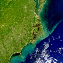
Extensive flooding led to overflowing rivers; nearly every river basin in eastern North Carolina reached 500 year or greater flood levels. Most localized flooding happened overnight; Floyd dropped nearly 17 in (430 mm) of rain during the hours of its passage and many residents were not aware of the flooding until the water came into their homes. The National Guard and the Coast Guard performed nearly 1700 fresh water rescues of people trapped on the roofs of their homes due to the rapid rise of the water. By contrast, many of the worst affected areas did not reach peak flood levels for several weeks after the storm, as the water accumulated in rivers and moved downstream (see flood graphic at right).
The passage of Hurricane Irene four weeks later contributed an additional six in (150 mm) of rain over the still-saturated area, causing further flooding.
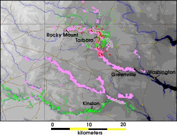

Flooded areas from Floyd along the Tar and Neuse rivers.
The Tar River suffered the worst flooding, exceeding 500-year flood levels along its lower stretches; it crested 24 ft (7.3 m) above flood stage. Flooding began in Rocky Mount, as much as 30% of which was underwater for several days. In Tarboro, much of the downtown was under several feet of water. Nearby, the town of Princeville was largely destroyed when the waters of the Tar poured over the town's levee, covering the town with over 20 ft (6.1 m) of floodwater for ten days. Further downstream, Greenville suffered very heavy flooding; damages in Pitt County alone were estimated at $1.6 billion (1999 USD, $1.87 billion 2006 USD). Washington, where the peak flood level was observed, was likewise devastated. Some residents in Greenville had to swim six feet underwater to reach the front doors of their homes and apartments. Due to the heavy flooding in downtown Greenville, the East Carolina Pirates were forced to relocate their football game against #9 Miami to N.C. State's Carter-Finley Stadium in Raleigh, where they beat the Hurricanes 27-23.
The Neuse River, Roanoke River, Waccamaw River, and New River exceeded 500-year flood levels, although damage was lower in these areas (compared to the Tar River) because of lower population densities. Because most of the Cape Fear River basin was west of the peak rainfall areas, the city of Wilmington was spared the worst flooding despite having the highest localized rainfall; however, the Northeast Cape Fear River (a tributary) did exceed 500-year flood levels. Of the state's eastern rivers, only the Lumber River escaped catastrophic flooding.
Rainfall and strong winds affected many homes across the state, destroying 7,000, leaving 17,000 uninhabitable, and damaging 56,000. Ten thousand people resided in temporary shelters following the storm. The extensive flooding resulted in significant crop damage. As quoted by North Carolina Secretary of Health and Human Services H. David Bruton, "Nothing since the Civil War has been as destructive to families here. The recovery process will be much longer than the water-going-down process." Around 31,000 jobs were lost from over 60,000 businesses through the storm, causing nearly $4 billion (1999 USD, $4.7 billion 2006 USD) in lost business revenue. In much of the affected area, officials urged people to either boil water or buy bottled water during Floyd's aftermath.
In contrast to the problems eastern North Carolina experienced, much of the western portion of the state remained under a severe drought.
Virginia []
Flooding in Franklin, Virginia.
As in North Carolina, Floyd produced torrential rainfall in the most eastern portions of Virginia, amounting to a peak of 16.57 in (421 mm) in Newport News. The rainfall led to overflowing rivers in the Chowan River Basin, some of which exceeded 500-year flood levels. The Blackwater River reached 100-year flood levels and flooded Franklin with 12 ft (3.7 m) of water. Extensive road damage occurred there, isolating the area from the rest of the state. Some 182 businesses and 150 houses were underwater in Franklin from the worst flooding in 60 years. In addition, two dams along the Rappahannock River burst from the extreme flooding. Throughout all of Virginia, Floyd damaged 9,250 houses, killed three people, and caused $101 million in damage (1999 USD; $133 million 2011 USD).
Mid-Atlantic []
Rainfall from Floyd.
By the time Floyd hit the shore, it was significantly weaker than it was at sea, due to the collapsing of its concentric eyes. This had little effect on the inland damage caused by the storm, however, and Floyd produced torrential rains and high winds throughout the Mid-Atlantic as far north as New York City and Long Island.
Chestertown, Maryland, reported a maximum rainfall total of 14 in (360 mm), with other locales reporting similar values. Extreme river flooding caused moderate damage to bridges and roads, resulting in a damage toll of $7.9 million (1999 USD; $10.4 million 2011 USD) throughout the state. In addition, over 250,000 residents were without electricity because of high winds blowing down power lines.
Rainfall amounts peaked at 13.34 in (339 mm) in Somerville, New Jersey, and 12.36 in (314 mm) in Vernon, Delaware. The Raritan River basin experienced record flooding as a result of Floyd's heavy rains, 4.5 ft (1.4 m) higher than the previous record flood crest. Bound Brook, New Jersey, was especially hard hit by a record flooding event: a 42-foot (12.8 m) flood crest, 14 ft (4.3 m) above flood stage, sent 12 ft (3.7 m) of water on Main Street and drowned three people.
Manville, New Jersey was hit nearly as hard, with record-breaking floods coming from the Raritan River and the nearby Millstone River, which join in Manville. Princeton University in Princeton, NJ, for several days declared municipal tap water unsafe to drink, advised students in dorms not to shower, and provided bottled drinking water.
The Rochelle Park, New Jersey hub of Electronic Data Systems was inundated by the nearby Saddle River, disrupting service to as many as 8,000 ATMs across the United States. Flooding in an adjoining Bell Atlantic switching facility cut off phone service to one million customers in the area.
Still a large tropical cyclone when it hit the Mid Atlantic states, Floyd produced a strong storm surge, peaking at 2.8 ft (0.85 m) with a storm tide of 9.34 ft (2.85 m) in Philadelphia with effects felt in parts of northern Pennsylvania including the Wilkes-Barre / Scranton metro area. Some 1,260,000 citizens across the three states lost power because of the storm, and flooding left many in Pennsylvania homeless.
In New York, over 10 inches of rain triggered mudslides on the bluffs overlooking the Hudson River near the Tappan Zee Bridge.

Floyd's rain affecting the Mid-Atlantic.
New England[]
Floyd caused large power outages and flood damage across New England, with over five inches (130 mm) of rain being dropped over most of the area. Danbury, Connecticut received up to 15 inches (380 mm) of rain from the storm, resulting in extensive flooding in the city and surrounding areas. Mudslides were reported in the Berkshire Mountains of western Massachusetts. Several major highways and a countless number of local roads in Connecticut and Massachusetts were closed for several days due to flooding, and downed trees and power lines. Because New England had been in a severe drought leading up to Floyd, the storm's floodwaters quickly receded. East of Floyd's center, large trees were uprooted by the storm's 70 mph winds, causing widespread power outages and minor structural damage.
Canada []
The remnants of Floyd continued into Canada entering the Canadian Hurricane Centre's area of responsibility on the evening and regional offices in Quebec and Atlantic Canada on September 16. Floyd became an extratropical low pressure system gradually losing strength and accelerating in the upper flow. In general, winds were below 90 kilometres per hour (56 mph) over Canada. However near Quebec City (Quebec province), the weather station on île d'Orléans recorded gusts up to 119 kilometres per hour (74 mph), and 83 km/h (52 mph) in the Maritimes. Damages to corn and other crops were recorded on the South shore of the Saint Lawrence River from the l'Amiante to Bellechasse regions, according to the Régie des assurances agricoles du Québec.
In the Maritime provinces, waves reached 9 metres (30 ft), equivalent of those caused by a winter storm. Rain fall was still substantial with up to 120 millimetres (4.7 in) over Eastern Townships and Beauce regions of Quebec, and the central part of New Brunswick. Region along the St.Lawrence River, between Montreal and Gaspé Peninsula, and Newfoundland received from 50 to 80 millimetres (3.1 in) Rain caused some damages to crops.
Aftermath[]
Criticism of FEMA[]
The Hurricane Floyd disaster was followed by what many judged to be a very slow federal response. Fully three weeks after the storm hit, Jesse Jackson complained to FEMA Director James Lee Witt on his CNN program Both Sides Now, "It seemed there was preparation for Hurricane Floyd, but then came Flood Floyd. Bridges are overwhelmed, levees are overwhelmed, whole towns under water ... [it's] an awesome scene of tragedy. So there's a great misery index in North Carolina." Witt responded, "We're starting to move the camper trailers in. It's been so wet it's been difficult to get things in there, but now it's going to be moving very quickly. And I think you're going to see a—I think the people there will see a big difference [within] this next weekend!"
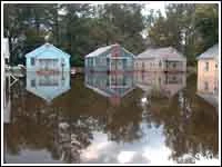
Flooding in Greenville, North Carolina on the Tar River.
Ecological effects[]

Runoff in the aftermath of the hurricane.
Runoff from the hurricane created significant problems for the ecology of North Carolina's rivers and sounds.
In the immediate aftermath of the storm, freshwater runoff, sediment, and decomposing organic matter caused salinity and oxygen levels in Pamlico Sound and its tributary rivers to drop to nearly zero. This raised fears of massive fish and shrimp kills, as had happened after Hurricane Fran and Hurricane Bonnie, and the state government responded quickly to provide financial aid to fishing and shrimping industries. Strangely, however, the year's shrimp and crab harvests were extremely prosperous; one possible explanation is that runoff from Hurricane Dennis caused marine animals to begin migrating to saltier waters, so they were less vulnerable to Floyd's ill effects.
Pollution from runoff was also a significant fear. Numerous pesticides were found in low but measurable quantities in the river waters, particularly in the Neuse River. Overall, however, the concentration of contaminants was slightly lower than had been measured in Hurricane Fran, likely because Floyd simply dropped more water to dilute them.
Retirement[]
Because of the severe damage it caused, the name Floyd was retired in the Spring of 2000 by the World Meteorological Organization. It was replaced with Franklin for the 2005 season. It was used during that season and not retired, so it is on the list of names to be used for the 2011 Atlantic hurricane season.
See Also[]
1999 Atlantic hurricane season