| Category 3 hurricane | |
|---|---|

| |
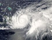
| Hurricane Jeanne as a Category 3 on September 25, 2004, approaching Florida | |
| Formed | September 13, 2004 |
| Dissipated | September 28, 2004 |
| Highest winds | 1-minute sustained:
120 mph (195 km/h) |
| Lowest pressure | 950 mbar (hPa; 28.05 inHg) |
| Fatalities | 3,035+ direct |
| Damage | $7 billion (2004 USD) |
| Areas affected | U.S. Virgin Islands, Puerto Rico,Dominican Republic, Haiti, Bahamas,Florida; flooding and damage in other eastern U.S. states |
| Part of the 2004 Atlantic hurricane season | |
History
Effects
Other wikis
| |
Hurricane Jeanne was the deadliest hurricane in the 2004 Atlantic hurricane season. It was the tenth named storm, the seventh hurricane, and the fifth major hurricane of the season, as well as the third hurricane and fourth named storm of the season to make landfall in Florida. After wreaking havoc on Hispaniola, Jeanne struggled to reorganize, eventually strengthening and performing a complete loop over the open Atlantic. It headed westwards, strengthening into a Category 2 hurricane and passing over the islands of Great Abaco and Grand Bahama in the Bahamas on September 25. Jeanne made landfall later in the day in Florida just 2 miles (3 kilometers) from where Frances had struck 3 weeks earlier. Building on the rainfall of Frances and Ivan, Jeanne brought near-record flood levels as far north as West Virginia and New Jersey before its remnants turned east into the open Atlantic. Jeanne is blamed for at least 3,006 deaths in Haiti with about 2,800 in Gonaïves alone, which was nearly washed away by floods and mudslides. The storm also caused 7 deaths in Puerto Rico, 18 in the Dominican Republic and at least 4 in Florida, bringing the total number of deaths to at least 3,025; Jeanne is the 12th most deadly storm in the Atlantic hurricane history ever. Final property damage in the United States was $6.8 billion, making this the 13th costliest hurricane in U.S. history.
Meteorological history[]

Storm path.
Tropical Depression Eleven formed from a tropical wave 70 miles (110 km) east-southeast of Guadeloupe in the evening of September 13, and was upgraded to Tropical Storm Jeanne the next day. Jeanne passed south of the U.S. Virgin Islands on September 15, making landfall near Yabucoa, Puerto Rico later the same day. After crossing Puerto Rico, Jeanne reached hurricane strength on September 16 near the eastern tip of the Dominican Republic on the island of Hispaniola, but fell back to tropical storm strength later that day as it moved across the mountainous island. Jeanne moved offshore the Dominican Republic late in the afternoon of September 17. By that time, Jeanne had weakened to tropical depression strength. Even though Jeanne did not strike Haiti directly, the storm was large enough to cause flooding and mudslides, particularly in the northwestern part of the country. On September 18, while the system was being tracked near Great Inagua and Haiti, a new center formed well to the northeast and the previous circulation dissipated. The system restrengthened, becoming a hurricane on September 20. Jeanne continued to meander for several days (making a complete loop in the process) before beginning a steady westward motion toward the Bahamas and Florida.
Jeanne continued strengthening as it headed west, passing over Great Abaco in the Bahamas on the morning of September 25. Shortly thereafter, the hurricane reached Category 3 strength. Jeanne maintained this intensity as it passed Grand Bahama Island. At 11:50 p.m. EDT on September 25 (0350 UTC September 26), Jeanne made landfall on Hutchinson Island, just east of Sewall's Point, Florida,Stuart, Florida and Port Saint Lucie, Florida, at Category 3 strength. This is the same place Hurricane Frances struck Florida three weeks earlier. Jeanne was the first major (Category 3 or higher) storm to make landfall on the East coast between Palm Beach, Florida and the mouth of the Savannah River since 1899.
Jeanne's track continued to follow within 20 miles (32 km) of that of Frances until it reached Pasco County. The cyclone then swung more rapidly to the north, and the center remained over land all the way to the Georgia state line, unlike Frances which exited into the Gulf of Mexico. Jeanne became an extratropical cyclone over Virginia on September 28 and the system moved back into the Atlantic offshore the New Jersey coast the next day.
Preparations[]

Hurricane Jeanne image at time of landfall on the Florida coast.

Hurricane Jeanne making landfall on the east coast of Hispaniola, September 16.
Puerto Rico and the Leeward Islands []
On the afternoon of September 13, tropical storm watches were issued for the British Virgin Islands, Saba, St. Eustatius, and St. Maarten while tropical storm warnings were raised for Puerto Rico and the U.S. Virgin Islands. The watches were upgraded to tropical storm warnings early on the morning of September 14. Later in the morning, tropical storm warnings were issued for St. Kitts and Nevis, while tropical storm watches were issued for Anguilla. During the afternoon, tropical storm warnings were lowered for Saba, St. Eustatius, and St. Maarten, while hurricane warnings were issued for Puerto Rico and the U.S. Virgin Islands. Late on the morning of September 15, a hurricane watch was issued for the British Virgin Islands. That afternoon, tropical storm warnings were dropped for St. Kitts and Nevis, while hurricane warnings were lowered to tropical storm warnings for the U.S. Virgin Islands. On the evening of September 15, tropical storm warnings were dropped Puerto Rico and the U.S. Virgin Islands, while hurricane warnings were downgraded to tropical storm warnings for Puerto Rico, and all watches and warnings were dropped for the British Virgin Islands. The entire power grid of Puerto Rico was shut down by the government of Sila Maria Calderón as the storm approached to prevent electrocutions and infrastructure damage.
Dominican Republic and Haiti []
Tropical storm watches were issued from Cabrera to Isla Saona early in the afternoon on September 14. Later that afternoon, hurricane watches and tropical storm warnings were raised from Cabrera to Santo Domingo. Late in the morning of September 15, hurricane warnings were issued from Cabrera to Isla Saona, while hurricane watches and tropical storm warnings were raised from Cabrera to Puerto Plata. That evening, hurricane warnings were extended westward from Cabrera to Puerto Plata while hurricane watches and tropical storm warnings were issued from Puerto Plata to Monte Cristo. Late in the morning of September 16, tropical storm warnings were issued from Le Mole St. Nicholas to Puerto Plata. That afternoon, hurricane warnings were downgraded to tropical storm warnings from Puerto Plata to Isla Saona while all hurricane watches were dropped. Late on the afternoon of September 17, tropical storm warnings were dropped for the remainder of Hispanola. After the 2004 Haiti rebellion that exiled Jean-Bertrand Aristide from power, the elected government were replaced with a new regime which did not protect the basic survival needs of the Haitian population, which leads to particularly bad consequences of Hurricane Jeanne.
Florida[]
Preparations in Central Florida were rushed and sudden, as it did not become apparent that the storm would make a direct hit until the morning of the 23rd. Indeed, it had appeared the storm would pass safely offshore just the night before. Voluntary evacuations were advised on Thursday Friday, plans for opening shelters on Saturday were distributed to the public, and Florida Power and Light warned that power could be out "for an extended period of time". Canals were also drained on the same day.
On Friday, the Palm Beach Zoo prepared for the storm by moving small animals and birds into buildings such as restrooms and restaurants. Evacuations began in earnest, with many residents leaving for the Keys, noting that the islands were the only location definitely out of harm's way. For once, evacuation to the Keys made sense.
The center of Jeanne's eye achieved landfall near Stuart, at virtually the identical spot that Frances had come ashore three weeks earlier, the first time in record keeping that a hurricane made landfall in the same place as a previous storm of the same season. Maximum winds at the time of landfall were estimated to be near 120 m.p.h.
Impact []
| Wettest tropical cyclones in Guadeloupe
Highest known recorded totals | ||||
|---|---|---|---|---|
| Precipitation | Storm | Location | ||
| Rank | (mm) | (in) | ||
| 1 | 508 | 20.00 | Marilyn 1995 | Saint-Claude. |
| 2 | 466 | 17.28 | Lenny 1999 | Gendarmerie |
| 3 | 318 | 12.50 | Hortense 1996 | Maison du Volcan |
| 4 | 300 | 11.81 | Jeanne 2004 | |
| 5 | 223 | 8.79 | Cleo 1964 | Deshaies |
| 6 | 200 | 7.90 | Erika 2009 | |
| 7 | 54 | 2.11 | Edith 1963 | Basse Terre |
| 8 | 41 | 1.61 | Emily 1987 | |
Puerto Rico was impacted by tropical storm force winds and heavy rain, with flooding on a historic scale. The storm made landfall near Maunabo midday on September 15. The storm generally moved northwest through the island, exiting on the northwest coast near the town of Mayagüez around 11 p.m. Jeanne passed directly over the towns of Arroyo, Patillas, Guayama and Salinas on its trip over the Commonwealth. San Juan reported a wind gust of 73 mph (117 km/h), Carolina reported gusts to 71 mph (114 km/h), and rainfall ranged from 5.98 inches (152 mm) in the city to over 24 inches (610 mm) in Vieques. This excessive rainfall resulted in damage to roads, landslides, and collapsed bridges. This resulted in one death and the evacuation of 400 people near the Río Grande de Añasco. A total of eight people were reported dead in Puerto Rico as a result of Jeanne. Damages from the storm were estimated at $169.5
million (2004 USD).
| Deaths from Hurricane Jeanne | ||||||
| Country | Total | State | County | County
total |
Direct
deaths | |
|---|---|---|---|---|---|---|
| Dominican Republic | 18 | 18 | ||||
| Haiti | 3,006+ | 3,006+ | ||||
| Puerto Rico | 8 | 4 | ||||
| USA | 5 | Florida | Brevard | 170 | 159 | |
| Clay | 10 | 30 | ||||
| Indian River | 111 | 135 | ||||
| South Carolina | Fairfield | 1 | 1 | |||
| Virginia | Patrick | 1 | 1 | |||
| Totals | 3,036+ | 3,593+ | ||||
Hispaniola []
By September 17, heavy rains totaling about 13 inches (330 mm) in the northern mountains of Haiti caused severe flooding and mudslides in the Artibonite region of the country, causing particular damage in the coastal city of Gonaïves, where it affected about 80,000 of the city's 100,000 residents. As of October 6, 2004 the official report counted 3,006 people dead, with 2,826 of those in Gonaïves alone. Another 2,601 people were injured,and 7 people died
In the Dominican Republic, the storm dumped torrential flooding rains and killing over two dozen. Damage totaled $270 million (2004 USD).
United States []
Millions in Florida were left without electricity, some for the third time in a month. There were only five direct deaths in the mainland United States, three in Florida, one in South Carolina and one in Virginia. The final US damage was determined to be around $6.9 billion, making it the 15th costliest hurricane in United States history. It was difficult to isolate this from damage caused by Hurricane Frances (and, around Polk County, and Highlands County, and from Hurricane Charley as well). While Jeanne was highly destructive, It almost killed a small child and his mom while evacuating a 4 star hotel in Port St.Lucie. They were rescued sometime after that.

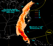
Storm total Rainfall from Jeanne.
As the storm moved northward east of the Appalachian Mountains, it continued producing heavy rains and flash flooding. Rainfall exceeded 6.00 inches (150 mm) as far north as New Jersey and Pennsylvania, resulting in severe flash flooding in Philadelphia, Pennsylvania and its Pennsylvania and New Jersey suburbs on September 28. Tornadoes also touched down in Wilmington, Delaware and Cherry Hill, New Jersey
.

Flooding in Haiti.
Delaware and Maryland []
Throughout Delaware, the remnants of Jeanne produced between 4 and 8 in (100 and 200 mm) of rain, peaking at 7.1 in (180 mm) at the University of Delaware. This led to widespread street flooding and several rivers overflowed their banks. Forty people had to be rescued from a bus along the White Clay Creek after the creek crested at .59 ft (0.18 m) above flood-stage. A strong F2 tornado touched down in the state, injuring five people and leaving $1 million in damages. The tornado touched down in northern New Castle County and tracked for 5 mi (8.0 km) and generated winds up to 130 mph (210 km/h). The county airport sustained significant damage, five C-130 cargo planes were damaged, thousands of pounds of jet fuel spilled, and damaged hangars. At a nearby industrial park, metal siding was torn off buildings, windows were shattered and power lines were downed. A self-storage facility sustained substantial damage.
In Maryland, Jeanne produced up to 4 in (100 mm) of rain, triggering flash flooding throughout the state. Numerous roads were flooded, including parts of Maryland Route 17. Several rivers rose above their flood-stage, with the Big Elk Creek cresting at 9.3 ft (2.8 m), 0.3 ft (0.091 m) above food-stage. A total of 50 roads were closed due to high water throughout the state. Numerous reports of stranded vehicles were sent to the Emergency Operations Center. In Carroll County, a group of inmates required rescue after the jail they were in flooded. One brief F0 tornado touched down in the state near Solomons, causing minor damage.
Retirement []
Due to very severe deaths and destruction in Hispaniola, Puerto Rico, the Bahamas and Southeastern United States, the name Jeanne was retired in the spring of 2005 by the World Meteorological Organization, and will never again be used for an Atlantic hurricane. It was replaced with Julia for the 2010 Atlantic hurricane season. Since the name Julia was not retired in 2010, it will also be used in the 2016 Atlantic hurricane season.