Hurricane Isabel was the ninth named storm, fifth hurricane, and the second major hurricane of the 2003 Atlantic hurricane season
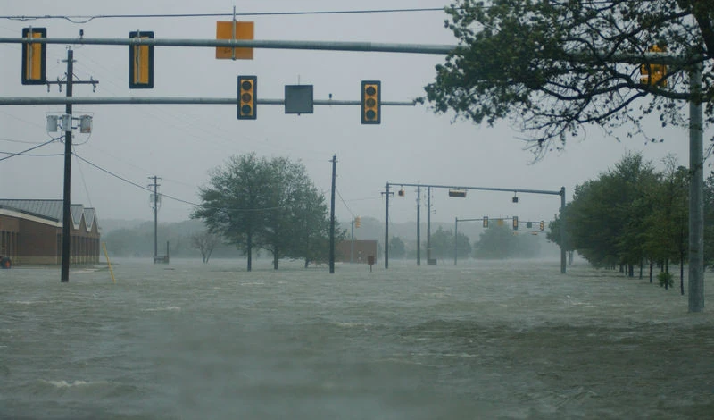
The storm's floodwaters in Hampton,Virginia
. Isabel formed on September 6 from a tropical wave that exited the coast of Africa on September 1. Isabel moved on a generally west-northwest path throughout its life, and although at first it was not certain if Isabel would impact the United States mainland directly, this ultimately became the case as Isabel made landfall in North Carolina on September 18 as a Category 2 hurricane on the Saffir-Simpson Hurricane Scale. Isabel, although not inherently powerful at landfall, produced a significant flood disaster for the Mid-Atlantic region as well as the northeastern United States, which had already been saturated by Tropical Storm Henri just over a week before. Isabel dissipated on September 20. Isabel was also the strongest and deadliest hurricane of the 2003 season, and also the longest-lasting storm of that season.
Finally, Isabel reached Category 5 status on three separate occasions, the first time since the 1980 season, when Hurricane Allen reached Category 5 on three separate occasions. The only storm in the Atlantic after Isabel to reach Category 5 on three separate occasions was Hurricane Ivan of 2004.
Isabel caused $3.6 billion (2003 USD) in damage and killed 51 people; 16 directly, and 35 indirectly.
Isabel seen from the International Space Station.
Fifty hours prior to the cyclone's landfall, the National Hurricane Center issued a Hurricane Watch from Little River, South Carolina to Chincoteague, Virginia, which included the Pamlico and Albemarle Sounds as well as the lower Chesapeake Bay. Also, the NHC issued a Tropical Storm Watch south of Little River, South Carolina to the mouth of the Santee River, as well as from Chincoteague, Virginia northward to Little Egg Inlet, New Jersey. Also, Hurricane Warnings and Tropical Storm Warnings were gradually issued for portions of the East Coast of the United States as Isabel drew closer. By the time Isabel made landfall, a Tropical Storm Warning existed for from Chincoteague, Virginia to Fire Island, New York and from Cape Fear, North Carolina to the mouth of the Santee River in South Carolina, and a Hurricane Warning existed from Chincoteague, Virginia to Cape Fear. Landfall forecasts for Hurricane Isabel were very accurate; from up to 3 days before landfall, the average track forecast error was only 36 miles, and the average track error for 48 hours was only 18 miles.
Officials issued mandatory evacuations for 24 counties in the states of North Carolina, Virginia, and Maryland, although in general, few people actually left. According to a survey done by the United States Department of Commerce, the evacuation rates are estimated as follows: 45% in the Outer Banks, 23% in the Pamlico Sound area, 23% in Virginia, and around 15% in Maryland. The threat that Isabel posed caused hundreds of thousands of residents to evacuate, mainly in North Carolina and Virginia, and it included that more than 12,000 residents stay in shelters. A total of 19 of the major airports across the East Coast of the United States were closed, and more than 1,500 flights were cancelled. Also, the Washington Metro and the Washington bus system were closed prior to the hurricane's arrival, and Amtrak cancelled nearly all trains south of the nation's capital. Also, schools as well as businesses in the cyclone's path were closed prior to the hurricane's arrival in order to allow sufficient time to prepare. Hardware and home improvement stores reported brisk businesses of plywood, flaslights, batteries, and portable generators, as residents prepared for the cyclone's impact. Excluding emergency staff members, the federal government was closed. The United States Navy ordered the removal of 40 ships and submarines and dozens of aircraft from naval sites near Norfolk, Virginia.
Impact[]
Throughout its path, Isabel caused $3.6 billion (2003 USD) in damage and killed 47 people, with 16 of those deaths being direct ones. Isabel was the worst hurricane to impact the East Coast of the United States since Hurricane Floyd of 1999.
Carribean and the Southeastern United States[]
High swells from Isabel affected the northern coastlines of the Greater Antilles. Strong swells also impacted the Bahamas. During most hurricanes, the location of the Bahamas relative to Florida prevents significantly high swells from impacting southeastern Florida. However, the combination of foward speed, the location, and also the strength of the hurricane produced strong swells in the Providence Channel onto a narrow 10 mile stretch of the southeastern Florida coast. At Delray Beach, waves reached as high as 14 feet. The high waves capsized a watercraft and it also injured the two passengers inside at Boynton Beach. Also, a swimmer required assistance to be rescued near Juno Beach. Also, minor beach erosion was reported in Palm County. Also, in the northern portion of Florida, waves were as high as 15 feet in Flagler Beach from the distant cyclone, which caused the Flagler Beach pier to be closed because of damaged boards from the high waves. Also, rip currents produced by Isabel killed one a surfer at an unguarded beach in Nassau County, with an additional six people having to be rescued from the rip currents. During the worst of the surf, the beaches were closed.
In northeastern South Carolina, Isabel's outer rainbands produced winds as high as 45 mph at Myrtle Beach. Rainfall was light, peaking at 1.34 inches in Loris. No damage was reported in South Carolina from Hurricane Isabel.
North Carolina[]
Hurricane Isabel produced hurricane force wind gusts throughout eastern North Carolina. The winds downed hundreds of trees, leaving up to 700,000 without power across the state. Damage from the hurricane totaled about $450,000,000 (2003 USD). Three people were killed in the state, two due to falling trees and one due to a utility worker attempting to restore electricity.
https://archive.is/20131014012015/img201.imageshack.us/img201/988/radarofisabelslandfallma1.png
Radar image of Hurricane Isabel making landfall in North Carolina.
Hurricane Isabel first began affecting North Carolina about 15 hours before it struck land. Upon making landfall along the Outer Banks, the hurricane produced strong waves of 15 to 25 feet (4.5 to 6 m) in height and a storm surge of about 6 to 8 feet (1.8 to 2.4 m). Waters reached a height of 7.15 feet in Hatteras. Storm tides along the coast peaked at 7.7 feet (2.3 m) in Cape Hatteras, though the total could be higher there due to the tide gage being destroyed by the hurricane. The surge and waves created a new inlet by washing out a portion of Hatteras Island between Hatteras and Frisco. Unofficially named Isabel Inlet, the break was 2,000 foot (600 m) wide and 15 foot (3 m) deep, and consisted of three distinct channels. The formation of the inlet destroyed a portion of North Carolina Highway 12, and also washed out three homes, dunes, power lines, and utility pipes. The new inlet destroyed all utility connections to Hatteras Village, isolating the residents there. The storm surge and waves from Isabel also resulted in a breach between Hatteras and Hatteras Inlet. The breach, which nearly became an inlet, formed from the flow of ocean water across the island, though it was not deep enough for a constant water flow. The breach occurred in an area without roads or houses, and had little impact on Hatteras residents. Rough surf and storm surge caused overwash and severe beach erosion throughout the Outer Banks, with flooding in Ocracoke reportedly being up to waist-high. The hurricane produced an estimated 4 inches (100 mm) of rain throughout most of the Outer Banks, with Duck reporting a peak of 4.72 inches (120 mm). Wind gusts in association with the hurricane peaked at 105 mph (170 km/h) in Ocracoke, with several other locations reporting hurricane force gusts. Wind and water damage across the Outer Banks was extensive. Strong waves and the storm surge from Hurricane Isabel knocked about 30 to 40 houses and several motels off of their pilings. Two families who did not evacuate were nearly swept out to sea when their home was destroyed. Local rescue was unable to reach them; however, they were ultimately able to reach safety. The rough waves greatly affected piers in Nags Head, Rodanthe, and Frisco, with three being completely destroyed. Several locations along North Carolina Highway 12 were partially washed out or covered with debris, and 15 foot (4.5 m) sections of pavement on both sides of a bridge near Ocracoke were washed away. Strong waves destroyed a beach access ramp, as well. Several thousand homes and businesses were damaged by the passage of the hurricane, and damage in Dare County totaled nearly $350,000,000 (2003 USD). In the Outer Banks, no deaths or injuries were reported.
https://archive.is/20131014012019/img201.imageshack.us/img201/3903/hatterasislandsd3.png
Hatteras Island, North Carolina before and after Hurricane Isabel.
https://archive.is/20131014011915/img292.imageshack.us/img292/2838/stormtidesix4.png
A graph showing storm tides from Hurricane Isabel.
https://archive.is/20131014011839/img292.imageshack.us/img292/2715/barrierislanddamageci9.png
Damage to barrier islands after Hurricane Isabel.
The effects of Hurricane Isabel were generally light in the southeastern portion of the state. Sustained winds reached 72 mph (116 km/h) offshore in the Frying Pan Shoals, where a gust of 82 mph (132 km/h) was also reported. Sustained winds were lighter along the coast, peaking at 45 mph (72 km/h) at the Wilmington International Airport, while gusts reached 66 mph (106 km/h) at a North Carolina State Ports Authority facility in Wilmington. Tropical storm force wind gusts were reported as far inland as Lumberton, where gusts reached 52 mph (54 km/h). The large circulation of Isabel dropped moderate rainfall across the area, peaking at 4.51 inches (115 mm) in Whiteville. Additionally, weather radars estimated over 5 inches (125 mm) of precipitation fell in portions of New Hanover County. The rainfall resulted in ponding on roadways, though no severe flooding was reported. Storm tides were generally around 1 foot (0.3 m) above normal, though Wilmington reported a storm tide of 3.22 feet (1 m). Rough waves resulted in moderate beach erosion near Cape Fear and minor erosion along eastward-facing beaches north of Cape Fear. Damage was minor in southeast North Carolina. Moderate winds inflicted isolated shingle and siding damage along barrier islands. The winds downed several trees, some onto cars and houses. Brief power outages were also reported. Beach erosion damaged a bridge in Bald Head Island, as well. In Chowan County, a business parking lot was under several feet of water due to flash flooding. One person was indirectly killed in Carteret County when trying to restore electricity.
https://archive.is/20131014012024/img201.imageshack.us/img201/3788/beachdamagefromisabelax0.png
A destroyed house in Kitty Hawk, North Carolina.
Isabel produced strong winds throughout inland areas of eastern North Carolina. Plymouth, located 75 miles (120 km) from where the hurricane made landfall, reported gusts to 95 mph (155 km/h). Sustained winds were lighter, with only a few locations receiving tropical storm strength winds. The passage of the hurricane resulted in moderate rainfall of up to 6.02 inches (153 mm) in Havelock. Upon making landfall, Isabel produced moderate to severe storm surges along the Pamlico and Neuse Rivers, with a location in Craven County reporting a storm tide of 10.5 feet (3.2 m) above normal. The strong storm surge produced significant flooding in Harlowe and Oriental. Several other locations also reported flooding of streets and low-lying areas. The rise of water flooded many homes in Craven County and the eastern portions of Carteret and Pamlico counties. Emergency personnel performed many rescues to people who had not evacuated and had become trapped by storm surge flooding. Several eyewittnesses reported high velocity, waist deep water moving homes, trailers, and other objects many yards inland. As the water retreated, these objects were then dragged back towards the sound. A 5 to 8 foot (1.5 to 2.4 m) storm surge struck the western portion of the Albemarle Sound, with significant surge flooding occurring to the west of Edenton. There, the surge destroyed four homes, two of which were moved up to 20 feet off their concrete block foundations. Nearly 60 percent of all homes and business in Chowan County suffered some structural damage due to wind, many of which were the result of large falling trees. One female died when a tree fell on her vehicle in Chowan County.
http://img165.imageshack.us/img165/4368/damageinedentonncyt3.png
Damage in Edenton, North Carolina.
Virginia[]
Isabel produced storm surge in Virginia, which peaked at an estimated 9 feet in the city of Richmond located along the James River; the surge caused significant damage to homes along the riverways, especially along the middle reaches of the James River basin. The surge surpassed the floodgate to the Midtown Tunnel while workers attempted to close the gate; around 44,000,000 gallons of water flooded the tunnel entirely in just 40 minutes, and the workers were barely able to escape.
https://archive.is/20131014012111/img444.imageshack.us/img444/3419/floodinginvirginiadw1.png
Flooding at Lagley AFB in Hampton, Virginia.
Heavy rainfall occured futher inland, peaking at 20.2 inches in Upper Sherando, which produced damage and significant flash flooding. Strong winds from Isabel destroyed over 1,000 homes and damaged around 9,000 more. Total damage in Virginia reached $1.85 billion (2003 USD). This makes Isabel among the costliest tropical cyclones in Virginia's history. Isabel also killed 32 people in Virginia; 10 of those direct; 22 of those indirect.
Maryland, Washington D.C., and Delaware[]
Due to Isabel, around 1.24 million residents lost power throughout Maryland and Washington D.C. The worst of the hurricane's effects came from storm surge, which flooded areas along the coast and resulted in significant beach erosion. In Eastern Mayland, hundreds of buildings were damaged or destroyed by tidal flooding from the hurricane, mainly in Queen Anne's County. Also, thousands of homes were affected in central Maryland, with severe flooding from storm surge reported in Baltimore and Annapolis. The nation's capital, Washington D.C., experienced moderate damage from the storm, mainly from high winds. Throughout Maryland Washington D.C., total damage reached $700,000,000 (2003 USD), with only one direct fatality due to flooding.
The effects from Isabel in Delaware were made worse by the flooding received by Tropical Storm Henri, which hit earlier in the month. Winds were moderate, peaking at 62 mph in Lewes. The winds downed numerous trees, power lines, and tree limbs across Delaware, which left at least 15,300 people without electricity. Also, numerous low-lying areas were flooded due to high surf, storm surge. Runoff from flooding occured further inland. Isabel caused $40,000,000 (2003 USD) in damage in Delaware, but killed no one.
Northeastern United States[]
Isabel produced strong winds in New Jersey, which downed hundreds of trees and power lines across New Jersey, leaving hundreds of thousands without power. Also, a falling tree killed one person. High waves as well as moderate storm surge caused moderate to severe beach erosion, and the rough waves also killed one person. Total damage in New Jersey from Isabel reached $50,000,000 (2003 USD).
In Pennsylvania, Isabel produced moderately high winds, which left 1.4 million residents without electricity in the state due to trees falling on power lines. The trees damaged dozens of homes as well as cars, as well. Also, one person suffered from carbon monoxide poisoning, which is believed to be the result of improperly ventilated generators in an area affected by power outages. Damage in Pennsylvania reached $160,000,000 (2003 USD), and 2 people died indirectly in the state.
In New York, fallen trees from strong winds downed power lines across the region, which caused sporadic power outages. Two people died in the region as a result of Hurricane Isabel, with both deaths occuring because of heavy surf. Total damage in New York reached $90,000,000 (2003 USD), and Vermont reported around $100,000 (2003 USD) in damage.
Midwestern United States[]
In West Virginia, Isabel produced wind gusts of 50 to 60 mph, which downed hundreds of trees across the state; previously heavy rainfall moistened the soil, which allowed the winds to uproot the trees more easily. The fallen trees severely damaged dozens of homes, and also left over 1.4 million residents in the state without electricity. Also, rainfall from the cyclone produced flooding along the rivers in the eastern part of the state. Total damage in West Virginia from Isabel reached $20,000,000 (2003 USD).
Isabel produced light to moderate rainfall across eastern portions of Ohio, with isolated locations picking up over 3 inches of rain from the storm. Also, moisture from Isabel caused light rainfall in eastern Michigan, peaking at 1.55 inches at Mount Clemens. Also, doppler radar estimates indicated that 2.5 inches of rain fell in St. Clair County. No damage was reported in the region.
https://archive.is/20131014011833/img444.imageshack.us/img444/2940/isabelrainfallfp3.png
Total rainfall reported from Hurricane Isabel.
Canada ey.[]
Isabel's impact in Canada was relatively minor, which included downed trees and power lines in southern Ontario. Also, the hurricane was indirectly responsible for one traffic fatality. A group of researchers flew into Isabel over Lake Erie as well as southern Ontario in order to study tropical cyclones transitioning into extratropical cyclones. Also, the group had flown two previous flights into past tropical cyclones affecting the region. it was really bad. ey.
Retirement[]
Because of the extreme damage, the name Isabel was retired in the Spring of 2004 by the World Meteorological Organization, being replaced by Ida for the 2009 Atlantic hurricane season.
See Also[]
2003 Atlantic hurricane season
References[]
http://www.nhc.noaa.gov/2003isabel.shtml?
http://en.wikipedia.org/wiki/Hurricane_Isabel
If people keep messing things up like this, it becomes unfair to others that want to use Wiki. So stop.